
CLASS FAQs
JPSS FAQs
- How do I Obtain OSTM/Jason-2 IGDR Data?
- Does the CLASS FTP server support restarting interrupted transfers? (3/05/07)
- How do I set up a subscription service? (9/22/06)
- How do I read my GOES satellite data? (8/18/06)
- What is the link for the ATOVS and AVHRR Pre-processing Package (AAPP)? (6/29/06)
- Can I Order Data on Physical Media? (5/22/06)
- Why are there multiple GOES data sets with numbers appended to the file names (e.g. -2, -3)? (5/8/06)
- I Am Having Problems FTPing My Data.
- How Can I Obtain a Number of Years' Worth of Data?
- I Cannot Connect to the CLASS FTP Server.
- How Can I Read the Data That I Just Obtained from Your Site? (7/17/06)
- When Are Data From New Satellites Made Available? (7/17/06)
- I Am Already a CLASS User But Have Forgotten My Password.
- Please Explain the Spatial Search.
- Why Do I Receive Data Outside of My Search Area?
- My Extracted Data Doesn't Seem to Match My Search Area.
- Where Can I Find Detailed Descriptions of the Format of the AVHRR, TOVS, and ATOVS Data?
- Historic Information Processing of Data Sets
- How Do I Become an Authorized RADARSAT User?
- Where do I find satellite and sensor status information?
- Satellite Data Viewing Software
- How can I use the Java Map?
- I Cannot Locate NOGAPS Type Files.
How do I Obtain OSTM/Jason-2 IGDR Data?
Does the CLASS FTP server support restarting interrupted transfers? (3/05/07)
How do I set up a subscription service? (9/22/06)
When you are approved for subscription service, you will see a link in the toolbar called Subscriptions after each log in. Clicking on this link will take you to the Subscription Summary page.
For more information and to preview a Subscription User Interface Demonstration please go to the Subscriptions Overview section.
How do I read my GOES satellite data? (8/18/06)
What is the link for the ATOVS and AVHRR Pre-processing Package (AAPP)? (6/29/06)
Can I Order Data on Physical Media? (5/22/06)
Why are there multiple GOES data sets with numbers appended to the file names (e.g. -2, -3)? (5/8/06)
I Am Having Problems FTPing My Data.
The CLASS FTP server is a Unix machine. The files stored in your FTP area are actually Unix links to files stored in other locations. Some Windows programs and Web Browsers mistakenly identify Unix links as directories and not as files. In most cases, you will be able to download the files anyway. However, in some cases, your FTP software will try to download the contents of the link.
If you are using an FTP program that does not follow the link but simply downloads it, please attempt the following:
Look for a newer version of the same program since later versions often will follow links.
Look at your configuration values for the program. Some programs have configuration options that allow the following of links.
Try using the FTP program provided with Windows.
Open a DOS window
Change to the directory in which you want your data placed.
Follow the FTP instructions CLASS sent to you in the Order Notification email.
Send us an email at class.help@noaa.gov with the name and version of the program. It is possible that we have already heard about your particular difficulty and thus could help you.
How Can I Obtain a Number of Years' Worth of Data?
CLASS does not limit the amount of data requested by a user. We only request that our users limit the number or data sets ordered to less than 500 a day. If you can satisfy your data needs by using the CLASS Web Interface, please do so.
However, we understand that there are some data requests for which use of the interface is impractical due to the amount of data needed. For these requests, it may be possible for CLASS to offer an offline solution. To explore this possibility, please send us email at class.help@noaa.gov identifying your data needs, your affiliation, and your intended use for the data. We will forward this information to the appropriate authorities for consideration. Please keep in mind that, because this service is time and labor intensive, there is a waiting list which may delay processing of your request. In many cases, you may be able to retrieve your data faster by using the CLASS Web Interface.
I Cannot Connect to the CLASS FTP Server.
This is usually a network problem. If you have been able to connect to our FTP server in the past, please try again after waiting for 15 minutes. If the problem persists, ensure that neither you nor your network administrators have made any changes to your network or firewall definitions.
If the problem continues, or if this is the first time that you have tried to connect to our site, send us an email at class.help@noaa.govwith the following information:
Date and time (GMT) of your attempt to connect.
The IP address or hostname that you were using to connect to us. If you do not know this information, the name of your Internet Service Provider (ISP) should suffice.
How Can I Read the Data That I Just Obtained from Your Site? (7/17/06)
If you are searching for ready to use images (GIF, JPG, NetCDF, Area etc.), the GOES Satellite Data may be an option. Also, some of the products in CLASS are available as image products such as the Sea Surface Temperatures derived from the POES data.
When Are Data From New Satellites Made Available? (7/17/06)
CLASS is scheduled to receive and distribute data from all NOAA POES and GOES satellites and from all DOD DMSP satellites. However, data from newly launched satellites are not initially considered operational. As such, the data are not available to the general public. CLASS makes the data available as soon as they are declared operational.
If you believe you have a legitimate need for pre-operational data, please email us at class.help@noaa.gov with your affiliation and a brief statement explaining your needs for the pre-operational data. We will forward your request to the appropriate authorities for consideration.
I Am Already a CLASS User But Have Forgotten My Password.
There have been some enhancements to the Log-In/Password procedures of CLASS.
For the full description of the enhancements and retrieval of your password, see the new Help Section provided at the following link: Log In
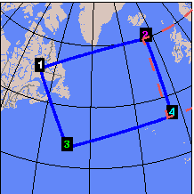
Please Explain the Spatial Search.
CLASS's spatial search detects not only the hits for which the subsatellite path (nadir) intersects your defined search region but also those in which the overlap between the given data set and your search region is only on the limb.
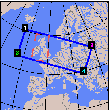
Since many of the hits may have only partial coverage, we recommend examination of the coverage of each hit to determine which ones meet your needs.
The following two examples are cases of such partial coverage:
|
|
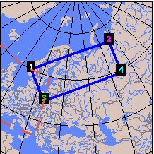
The search greatly improves the determination of the overlap between the search area and the individual hit. See example below. Note that CLASS's data extraction for subsetted data gives you each and every scan that intersects your search region.
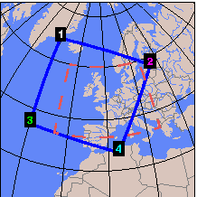
The search better determines the boundaries of the browse images and accurately matches the browse images with the indicated overlap area. The search also improves the accuracy of the estimation of the size of ordered data sets.
The new algorithm shows significant improvement in its polar search capabilities. Searches near a pole do not yet detect all non-nadir hits, but this issue will be addressed in an upcoming release.
In the past, some users would artificially increase their search areas to try to capture non-nadir hits. This expansion is no longer necessary. You should simply specify your true area of interest.
This robust search may be somewhat slower than the previous search. However, we believe its increased capabilities and reliability more than makes up for the usually modest increase in search times. Future releases will aim to improve the search speed.
Note that the spatial search described above does not apply to SAR data. A separate search algorithm is used for SAR data.
Please contact CLASS User Assistance at class.help@noaa.gov if you have any questions or comments regarding the new geographic search algorithm or plans for further search improvements.
Why Do I Receive Data Outside of My Search Area?
When you perform a spatial search and order subsetted data from CLASS, the data extraction system will produce a file containing each and every scan which intersects your defined search region. A scan will be included even if only a small portion touches your area and the entire scan will be included even if most of it is outside of the search region.
My Extracted Data Doesn't Seem to Match My Search Area.
When a user requests geographic selection when ordering an entity, CLASS's data extraction software selects each and every scan which has any overlap with the user-defined region. Consecutive passes within a single global data set (4KM AVHRR) may intersect the user region. If this happens, the extracted data set will include those scans from the first pass followed immediately by the scans from the second pass. There will be nothing in the data set to indicate the end of the first intersecting region and the beginning of the next.
CLASS cannot attest to the ability of any of the Satellite Data Viewing Software to properly separate the two regions. The user should be aware that multiple regions may exist. This phenomenon is more prevalent for larger or more poleward user-defined regions.
Where Can I Find Detailed Descriptions of the Format of the AVHRR, TOVS, and ATOVS Data?
Detailed information on the AVHRR and TOVS data types for satellites TIROS-N through NOAA-14 can be found in the NOAA Polar Orbiter Data User's Guide at www2.ncdc.noaa.gov/docs/podug/
Details of the AVHRR and ATOVS data from satellites NOAA-15 and NOAA-16 can be found in the NOAA KLM User's Guide at www2.ncdc.noaa.gov/docs/klm/
Historic Information Processing of Data Sets
Current Status of Historic Information Processing of Data Sets at CLASS
The Historic Information Processing (HIP) of data is designed to make all NOAA (AVHRR & TOVS) and DoD (DMSP) data available on-line via CLASS. Currently, 83% of this historic data is now available on-line. At the completion of HIP, 100% of the data will be available on-line. The table below contains more detailed statistics. |
HISTORICAL DATA SET STATISTICS |
|||
Data Type |
Historic Period |
Data Sets On-Line |
Data Sets Off-Line |
AVHRR/GHRR |
08/24/81 - 12/31/94 |
102,922 |
26,993* |
AVHRR/LHRR |
10/21/88 - 12/31/94 |
61,782 |
33,724* |
AVHRR/HRPT |
10/21/88 - 12/31/94 |
36,458 |
21,840* |
TOVS/MSUX |
10/21/78 - 06/13/95 |
160,543 |
3,302* |
TOVS/HIRX |
10/21/78 - 06/13/95 |
160,050 |
3,953* |
TOVS/SSUX |
10/21/78 - 06/13/95 |
81,426 |
2,513* |
DMSP/SSMT |
07/15/91 - 02/17/97 |
48,788 |
11,204* |
DMSP/SMT2 |
06/01/94 - 02/17/97 |
14,459 |
1,823* |
DMSP/EDRR |
08/22/91 - 02/18/97 |
0 |
48,772** |
DMSP/SDRR |
08/22/91 - 02/18/97 |
0 |
40,888** |
DMSP/TDRR |
08/22/91 - 02/18/97 |
0 |
48,861** |
TOTALS |
666,338 |
248,729 |
|
Legend: |
* started |
** not started |
How Do I Become an Authorized RADARSAT User?
Refer to our Data Documents here for details on becoming a RADARSAT user.
Where do I find satellite and sensor status information?
Information regarding the status and condition of various satellites and sensors supported by CLASS is available at the following links. These sites may be useful in explaining problems you may be experiencing with some of your data.
Additionally, the PPP web site provides notices on changes impacting Level 1B data.
Satellite Data Viewing Software
The CLASS User Assistance Team receives many inquiries regarding the availability of visualization software packages for viewing data ordered from CLASS. There are many sources for packages that provide satellite remapping and analysis functions. The following are just a few of the organizations offering commercial packages or freeware to provide this capability. CLASS does not endorse any of the following packages or vendors.
Organizations or individuals whose software is not listed may have it included by contacting class.help@noaa.gov.
The following links are outside of the CLASS domain. You may wish to check their privacy policy.
The equidistant cylindrical flat map is a Java applet. You need to adjust your browser's configuration to allow Java applets. If your browser is configured to allow applets, the map will appear automatically.
I Cannot Locate NOGAPS Type Files.
Starting on August 1, 2013, FNMOC is replacing their NOGAPS model with the NAVGEM (Navy Global Environmental Model) model. NOGAPS were effective from October 28, 2011 to July 31, 2013. CLASS will no longer receive files of the NOGAPS type from IDPS, but rather ODAD files that related to FNMOC.